In the field there will be trees that need to be positioned again or for the first time. We have photo-trees with estimates for the XY(Z) position that can be used for the positioning of the other trees / objects.
The photo-trees have XYZ coordinates for the treetop. For vertical stems, these XY coordinates have an accuracy of approximately 0.25 m in X and Y. This is the precision using large-scale aerial images. For slant trees or trees that have an ambiguous apex, the imprecision is larger and these trees should not be used for the positioning of new objects.
A compass can be used for observing intertree azimuths. If we measure the azimuth of a "line" connecting a photo-tree and an unknown tree, we have an estimate for a half-line that has an end point at the XY-location of the photo-tree and the half-line points to the direction of the observed azimuth. Recall that an azimuth angle takes values between 0 and 360 degrees and the angle has a clock-wise positive direction. The second intertree azimuth observation defines a half-line that has an exact intersection with the first half-line, and this could be used for the positioning of the unknown point. The third observation from a third photo-tree towards the unknown point is redundant, but informative. Now the 3 half-lines no longer intersect in a point, but there is dispersion of the lines around a point that now needs to be defined/calculated by some other means. It is possible to find an XY point that minimizes the sum of squares of the azimuth residuals (triangulation).
Intertree distances between known photo-trees and the unknown tree are an alternative or complement to intertree azimuths. One intertree distance defines a circle around the photo-tree, second distance defines another circle that has from 0 to 2 intersections with the first circle. Thus two intertree distances are not enough. After the third intertree distance we have a situation where it is possible to find a point that is "closest to the circles" or a point that minimizes the sum of squares of the distance residuals (trilateration). Satellite positioning is based on interpoint 3D distances - here distances refer to horizontal XY distances as we are not intrested in the Z, which is assumed to be known from the DTM.
Let us denote the unknown point as P0 and the photo-trees as PA, azimuth observatios alpha and the distances with d. For least square adjustment we need observation equations that can be used for calculating the residuals that are then minimized (their sum of squares will be minimized). These are given in Fig. 1. Note that points PA are also treated as unknowns, since their photogrammetric coordinates are erroneous with an a priori standard error of ca. 0.25 m.
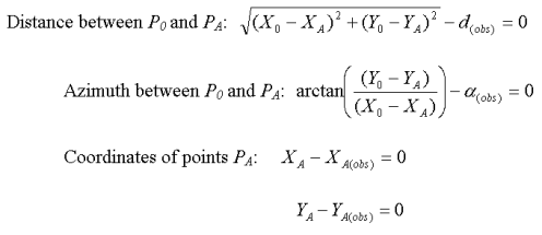
Fig 1. Observation equations of combined triangulation and trilateration.
(X0,Y0) are the (unknown) coordinates of the unknown point. (XA, YA) are the (un)known and slightly erroneous photogrammetric coordinates of the photo trees. d(obs) is the observed intertree distance (with a rangefinder). alpha(obs) is the observed azimuth (with compass).
Ordinary least square adjustment (OLS) cannot be applied in solving the coordinates of points P0 and PA, since they are non-linear parameters in the observation equations with square root() and arctan() in Fig. 1. This means that iterative LS-adjustment is needed, where the unknowns, especially coordinates of point P0, need initial approximations. Also, there are now three types of residuals: (1) distance [m], (2) azimuth [rad] and (3) coordinate [m] and we need to normalize them before the sum of their squares (inner product) is computed and minimized. For that we apply WLS, weighted least square adjustment. In it, each residual is weighted with the reciprocal of its a priori standard error, which need to be known somehow. "Good values" are 0.25 m for coordinates of points PA, 0.02 radians (~1 degree) for azimuth observations and 0.05 m for intertree distances. These values reflect rather carefull field work and photogrammetric observation accuracy. With such a good measurement precision and several observations, it is possible to reach an accuracy of 0.2-0.3 m (Fig 3).
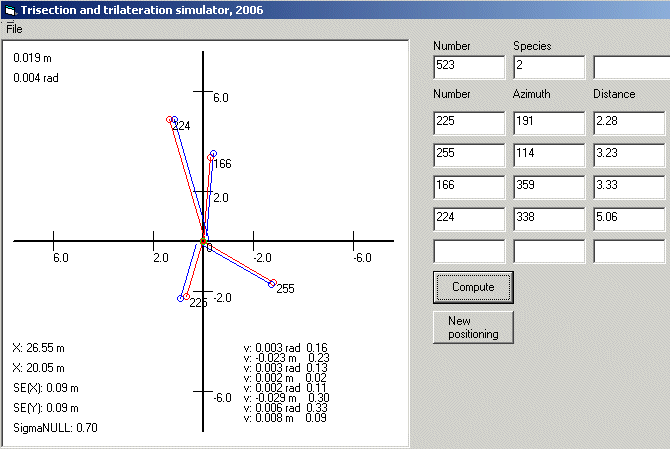
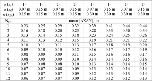
Fig 3. This table gives the mean lenght of the XY-error vector (L2 norm) as the accuracy measure of the positioning method. NPA is the number of photo-trees (1-12). Columns reflect different scenarios of the measurement imprecision of the photogrammetric coordinates (0.15 m or 0.30 m), the intertree azimuth observations (1 or 2 degrees) and the intertree distances (0.07 or 0.15 m).
Notes
- The method is implemented in a program (Fig 2) that is used in the office, since we do not have enough field-computers. This means that field observations should be done with care to avoid errors that are difficult to detect afterwards.
- The method is applicable only in areas where magnetic anomalies do not exist. Under such conditions, only the intertree distances are reliable.
- When distances or azimuths alone are used, the constellation
of the photo-trees is important for optimal geometry (comparable with. #DOP
values in satellite positioning)