The program operates on the 2004, sparse LiDAR, and estimates the 5 variables for circular plots (r=11.28 m). The IDs and XY positions of the plots are given in an ASCII file C:\data\marv4_alat.txt. You can change values in this file, and study, for example what happens if the XY-grid moves 1 m to North.
The DTM is needed for computing the above ground heights for the LiDAR points. It is a 26 MB binary file that has an associated ASCII-header.
The ALS2004 1-hactare binary files (*.bin) are needed, and they should be in folder c:\data\als2004\Repros\Bin\. They require storage of 1.12 Gb.
Zip-file with Windows executable and source
Windows executable.
The program execution has three steps:
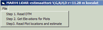
In step one, read the hdr-file for the DTM.
In step two, the program calculates terrain elevations for the plots.
In step three, the marv4_alat.txt file is read, and the 5 variables are estimated.
Output is stored in c:\data\Regression_results.txt. It contains values for plotID, X, Y, Volume [m3/ha], Basal area [m2/ha], Stem number [n/ha], mean height [m], mean diameter [cm]