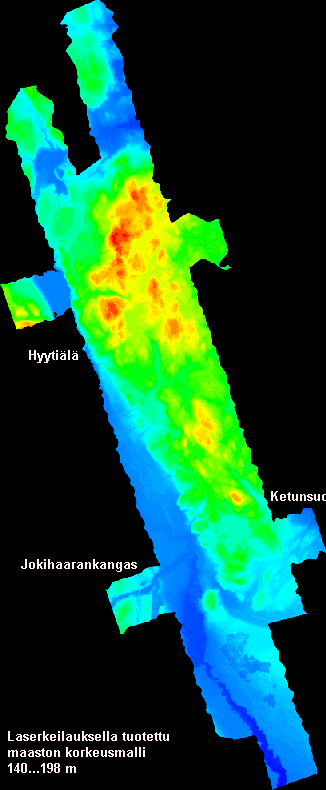
Fig. 1. The coverage of the DTM is approximately 1.5
x 6 km. The Lapinkangs glacial delta is in the south. Most values in the
DTM are "N/A". The HSV-coloring ranges from 140 m to 198 m.
Back to index,
Next
The DTM was made using Terra-software modules. The algorithm that filters terrain hits from the rest of the LiDAR data is described in Axelsson (1999, ISPRS JPRS). It has three major parameters that affect the performance. These were tried in 100 different combinations, and the best DTM was selected using some 8300 test points in Hyytiälä, which were tree butts in 27 permanent sample plots, where trees had been measured using a tacheometer.
The ground points formed a TIN in TerraModeler, which was further interpolated into a grid of 1-m resolution. This was made into a binary file that has the N60-elevations in single precision (4 byte) decimal numbers. Because of the high resolution (4054 x 9855 cells), the file size is 156 Mbytes (Fig. 1).
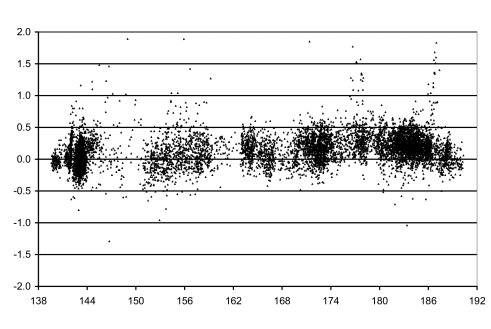
Fig.2. The residuals (x N60) of 8329 test
points in 27 permanent sample plots representing stands with tree heights
varying from 12 to 30 meters. The LiDAR-DTM was 0.14 m below the test points
and the overall RMSE was 0.27 m. Note that part of this inaccuracy is due
to field measurement errors in the reference values. The actual accuracy
of the DTM is therefore better, app. 25 cm, but there seems to be underestimation
of N60-elevations under canopy, whereas in seedling stands the LiDAR DTM
is slightly above the true surface. This is likely due to the forest bottom
flora that has its succession and phenology. The 2004 LiDAR that was used
for DTM estimation was done in August, under leaff-on conditions.
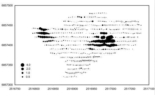
Fig. 3. Example of DTM errors in a 2-yr old seedling stand (250 x 100 m). Two small hills are missing from the DTM. The reference elevations here were obtained using VRS-GPS positioning.
Fig. 3. Example of DTM errors in a 2-yr old seedling stand (250 x 100 m). Two small hills are missing from the DTM. The reference elevations here were obtained using VRS-GPS positioning.